


Teide

jcm17
User
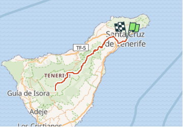

Length
137 km

Max alt
2381 m

Uphill gradient
3711 m
Km-Effort
187 km

Min alt
-1 m

Downhill gradient
3714 m
Boucle
Yes
Creation date :
2023-01-27 08:39:35.737
Updated on :
2023-05-07 14:28:00.772
4h17
Difficulty : Very easy

FREE GPS app for hiking
 SityTrail
IGN / Geographical institutes
SityTrail Plus
The world is yours!
About
Trail Car of 137 km to be discovered at Canary Islands, Santa Cruz de Tenerife, Santa Cruz de Tenerife. This trail is proposed by jcm17.
Positioning
Country:
Spain
Region :
Canary Islands
Department/Province :
Santa Cruz de Tenerife
Municipality :
Santa Cruz de Tenerife
Location:
Centro-Ifara
Start:(Dec)
Start:(UTM)
378382 ; 3149911 (28R) N.
Comments